Representative End User Clients


Representative Automation Clients
Representative Software Clients


Companies operating in the oil & gas industry often possess disparate and distributed complex assets, are running operations often in remote and harsh environments which put employees in harm’s way or may operate in confined areas that are often GPS-denied. Heavy process industries, such as oil & gas, face several challenges that make realizing operational excellence, or at least operational improvements, paramount for continued success and  profitability. Oil & gas companies are selectively investing in technologies that can help digitize their operations, save time and money, and help increase operational visibility, flexibility and agility.
The need for greater operational visibility into a range of complex assets such as a compressor station or a facility as large as a refinery is often challenged by reliance on dated processes or technologies. While many of these operations possess an abundance of data, often much of this data is analog or paper based, or data is often missing or of poor quality and consistency. Traditionally, manual inspections in many oil & gas operations have been unsafe, inefficient, time consuming and expensive; and to make matters worse, most of the data is not actionable since it is not digital. Consequently, oil & gas companies are investing in new technologies designed to help digitalize their operations and help enable safer, remote operations.
Increasingly, oil & gas companies are starting to rely more on drones to supersede traditional inspection approaches as drones enable them to capture data more quickly and safely, as well as provide greater insight into the condition and monitoring of changes over time of physical assets and their surrounding environment.
ARC was briefed recently by Emesent on how their unique Hovermap solution was deployed to simplify detailed data capture to create a digital twin of a complex asset for an onshore oil & gas operation located in the southeastern United States.
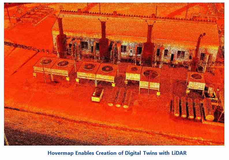
Aerial Production Services (APS) is a provider of aerial inspections in the oil & gas, construction, and telecommunications industries. To accurately capture a digital model of a large onshore natural gas compressor station, APS selected Emesent’s Hovermap. Hovermap is a unique and powerful Simultaneous Localization and Mapping  (SLAM) LiDAR system which enables the capture of 3D point cloud data of an entire asset, quickly and safely by scanning both indoors and outdoors, as well as above, below and between the various equipment such as pipelines, mainline valve stations, yard piping, filtration, liquid separation vessels, cooling towers, various utilities, compressor skids, and export pipe-related infrastructure. Using Hovermap, APS was able to scan the entire facility in just two 25-minute flights, using the outputs as the basis to create a digital twin.
Hovermap enables the capture of 3D point cloud data of a complex asset using a single, versatile technology and workflow since it enables data capture above and below ground, indoors and out and is easily switched from a drone flight to a walking, vehicle, mobile robot, or a backpack-mounted scan, depending on requirements.
The Emesent Hovermap solution is LiDAR based and does not require GPS. Instead, it uses a powerful SLAM algorithm to estimate the drone’s position and orientation from the LiDAR data itself and create high-detail, accurate 3D point clouds. Hovermap not only provides this mapping capability, but it also provides advanced autonomy capabilities. It allows the drone to fly autonomously, self-navigating around 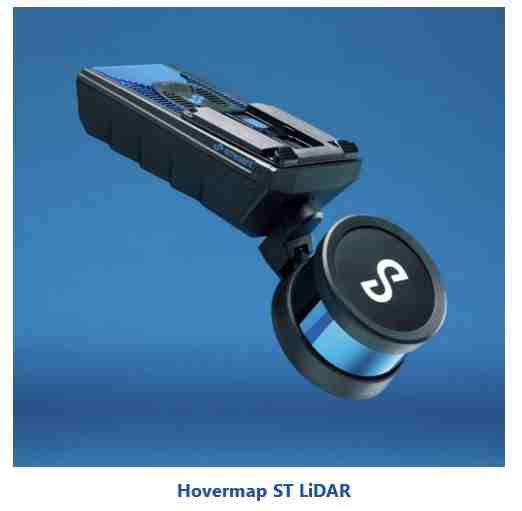 obstacles even in GPS-denied environments and beyond line-of-sight and communication range.
Emesent’s latest product, Hovermap ST is a tough, lightweight and IP65 rated (dust and splash resistant) solution, allowing the user to map in severe environments, rain, or shine. It can operate in temperatures from -10 to 45° C (14 to 113° F) as well as high humidity, making it ideal for use in hot desert-based oilfields, remote offshore platforms, underground mines, and other harsh environments. Emesent is raising the bar for drone autonomy with their autonomous capability for Hovermap, enabling venturing into previously inaccessible areas to capture data and deliver valuable insights.
Hovermap pilots can fly an entire mission, from take-off to landing, using only a tablet. Data is processed on-board in real-time to stream a 3D map back to the operator. Tapping on the map will set smart waypoints, and Hovermap takes care of the rest, navigating to the waypoints while avoiding obstacles and completing the mission autonomously.
Sparked by the once in a century pandemic, oil & gas companies are increasing investments in technologies that enable and empower remote, and, in the future, autonomous operations as they continue to grapple with price volatility, financial pressure to cut costs while maintaining production, and a winnowing workforce in both numbers of employees and relevant experience. Solutions such as Hovermap will be leveraged on drones and ground-based robotics to provide autonomous data capture and high-resolution 3D scans for detailed digital twins which will provide real-time operational visibility, agility, and flexibility.
Drone technology continues to improve the capture of useful data with the advancement of LiDAR. The development of Simultaneous Localization and Mapping (SLAM) based autonomy now provides the ability to operate in GPS-denied environments using lightweight precision LiDAR carried by a drone. This autonomous capability means that LiDAR can operate in previously unmapped dark, confined spaces like tanks at refineries with minimal human involvement. This ability can improve oil & gas operations and gather valuable data without putting humans into hostile environments or to work on dangerous tasks.
ARC follows the drone markets for asset inspection and delivery. This new inspection technology is another example of how drones can provide useful data that improves the operation of industrial activities by expanding data collection and analysis into GPS-denied spaces. Emesent will be participating in ARC’s 26th Annual Industry Forum session “Drones Empowering Automation and Inspections” on June 9, 2022. and a speaker from Aerial Production Services will be highlighting how the deployment of Hovermap solution helped to create a digital twin of a compressor station; helping to increase safety, reduce inspection times, reduce post scan processing time, and enable comprehensive automated data capture using a single versatile tool.
ARC Advisory Group clients can view the complete report at ARC Client Portal
If you would like to buy this report or obtain information about how to become a client, please Contact Us
Keywords: LiDAR, Autonomy Payload, Drones, Hovermap, Drone Inspection, Robotic Inspection, Oil & Gas, ARC Advisory Group.