The smart city presents new challenges for visualizing data in both the central operations center capacity, as well as, presenting cyber-physical networks to a predominately mobile workforce. For the centralized or remote operations control rooms, we are now seeing 3D/4D/5D digital city models and even digital twin for cities. For mobile operators, vendors are beginning to bring augmented and mixed reality capabilities for mobile workers and citizens/tourists applications. The scale and complexity of designing, building, monitoring, operating, and maintaining a smart city will require advanced visualization solutions that present data and simulation technologies in ways that previous systems did not require. Systems will need to show users where things are in a way that is familiar to them (google earth model), as the old school linear system architecture of an HMI would not be even possible and tables of device data would have zero context without location. ARC believes advanced visualization platforms such as Digital Twin will be required to design, build, monitor, control, operate, and maintain a smart city.
Digital Twin
“Digital Twins” are a digital representation of a piece of real equipment that is created at the design phase. This virtual copy is then used during operations and maintenance to visualize the product and provide IoT-related services. Three prominent vendors are offering smart city “digital twins”,
Dassault Systèmes,
GE Digital and
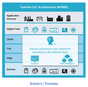
Toshiba IoT. Dassault has partnered with Singapore to create a digital twin called “Virtual Singapore,” which is slated to launch by the end of this year. The virtual twin will help urban planners and policymakers visualize the insights gained from various sensor networks and intelligent systems deployed now and in the future and use them to make informed decisions. GE has taken it another step further, offering what they dub a “Digital Ghost,” or a virtual copy of a city’s control system for security purposes to recognize anomalies and create alerts for further investigation. The video below provides further insight into this visionary project to build a Virtual Singapore.
[embed]https://youtu.be/Dix-8SNxlAo[/embed]
The Virtual Singapore interface allows you to pilot throughout the city as if you are a drone with a mounted camera, and by mouse clicks, zoom -in and -out and view virtual objects with layers of associated information. An aerial view of the city provides information such as traffic and weather conditions, while zooming in on a facility will reveal granular intelligence such as dimensions, engineering specs, building materials, energy usage, number of residents, parking spaces and even the units rental cost. The “Digital Twin” concept is revolutionizing product lifecycles today, but the impact of taking this technology and applying it to the scope of a smart city is "mind blowing".
Cityzenith’s 5D Smart World™ Platform Goes Live Today
3D/4D/5D smart city information models are using digital imagery integrated with available data sets and overlaying IoT networks with contextual data schema to create a virtual representation of an entire city metro area's cyber-physical assets. Cityzenith’s “Smart World” visualization platform utilizes data analytics powered by GE Current’s CityIQ™ IoT platform. “Smart World” won the prestigious Digie Award for "Best Technology Innovation in Commercial/Corporate Real Estate of 2016" at Realcomm.
Cityzenith’s next-generation visualization platform will transform the way smart cities are designed, managed, and operated. The infrastructure development process will be digitized and enable a more integrated digital lifecycle including smarter design, collaboration, analysis, operations, and data presentation capabilities. Developed by the original creators of Google Earth™ 5D Smart World™ is a format-agnostic 3D model environment. This simplifies the process of importing, consolidating, analyzing, and reporting any information from virtually any source. Smart World is already being used for projects in over 100 cities in 12 countries, including many leading smart cities such as Chicago, London, and Doha.
Other Notable Examples of Advanced Visualization Solutions for Smart Cities
Tenqyu
- Mobile Apps Powered by Augmented Reality
Bentley SIRADEL
- Solutions for smart city planning are built as a pyramid, with 3D data as the foundation, and completed by software and services.
- SIRADEL’s Smart City ExplorerTM is an open and collaborative platform with advanced features for interactive 3D visualization, simulation and planning of any kind for urban infrastructure projects.
- Services include massive geodata management, radio, urban and software engineering, and customized 3D tools
N3N
- INNOWATCH, an innovative platform managing all of your data sources, facilities, business operations, and monitoring systems from a single station in real-time.
- Features N3N's patented pan and zoom technology, custom mapping generator with pixel on demand and adaptive streaming technology. This technology allows N3N to provide live streams from around the globe directly to any operations center.
CivicConnect

- CivicAR Mobile Platform - enables applications to instantly make information available to the user in the context of the real world through AR.
- Supported by the CivicConnect Platform, a data management, development and deployment platform for the public sector.
- CivicConnect Urban Mobility, CivicConnect Economic Development and CivicConnect Asset Management are built on top of the CivicAR Mobile Platform.